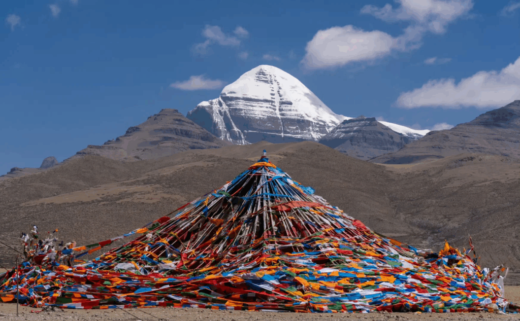
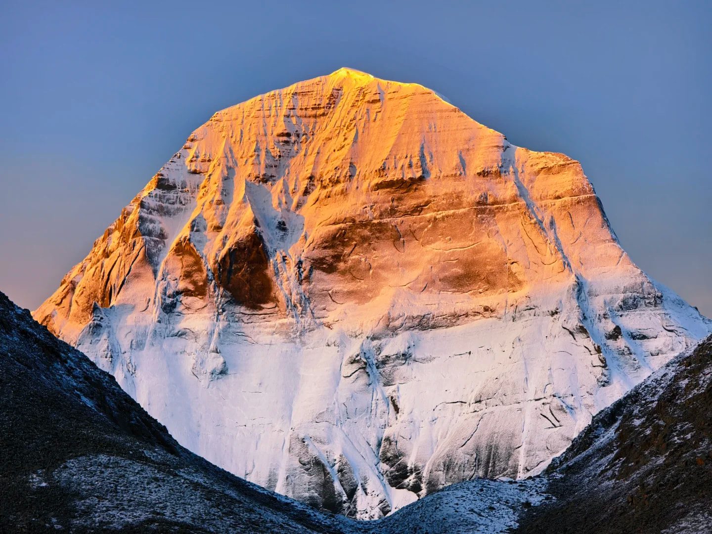
Mount Kailash, at an altitude of 6,638 meters, stands in Pran County, Ali, Tibet. This pyramid-shaped mountain is sacred to Tibetan Buddhism, Hinduism, Jainism and Bön Buddhism, and is the only mountain in the world to straddle all four religions.
This article is a complete analysis of every key to this trip to Ali, from the background of faith, to the route of transmigration, to the safety of the plateau.
González: Geography and Faith Background
geographic location
Located at the crossroads of the Himalayas and the Gondis, Gang Rinpoche is a mountain with steep walls, clear ridges and year-round snow. On a clear day, the contrast between the blue sky, the sea of clouds and the snow-capped peaks is strong, making it an ideal place for photography.
Four of Asia's great rivers - the Indus, the Yarlung Tsangpo, the Satrej and the Karnali - all originate in the vicinity of this mountain, making Gang Rinpoche truly the "center of the world" in a geographical sense.
Topography and Visual Features
The mountains of Gang Rinpoche have clear ridges, distinct rock layers and a cold sense of light under sunlight; the contrast between the blue sky, sea of clouds and snowy peaks is strong on clear days, making it an ideal subject for photography.
Transportation and Accessibility
The majority of travelers fromLhasaDepart from Tibet and travel westward along the New Tibet Route or the Ali Southern Route; due to the long distance and increasing altitude, it is recommended to travel in sections and arrange for intermediate stops to facilitate adaptation. (Foreign travelers are required to hold a Tibet entry permit and follow a qualified travel agency, and are not allowed to travel freely.)

Why Mountains Are Considered Sacred: Beliefs and Symbols
Gonzalo González is in theTibetan BuddhismIt is regarded as the Vajra Dojo of Seungrak; in theHinduismIt is regarded as the abode of Lord Shiva;Jainism..IslamIt is also regarded as a sacred place. The inter-religious veneration makes it a place of pilgrimage, practice and spiritual healing.
Cultural Experience Proposal
Respecting local customs, following trail rules, and keeping the environment quiet and clean are the basic etiquette for getting close to the sacred mountain. It is recommended to shoot in the villages or monasteries within the periphery of the activity area to avoid interfering with the religious activities.
Overview of mountain climbing: routes, distances and altitudes
The total length of the Outer Circle Trail of the Gang Rinpoche is about 1,000 meters.52 kilometersMostly in the form ofTachin (about 4,675m)The trail begins and ends at a point where the trail follows valleys, glacial rivers, and mountain passes.Dromola PassThe highest point is about5,648mThe General Recommendations2-3 daysFinish, emphasize on rhythm and safety; one-day speed spinning for top athletes is a high-risk behavior and not recommended for most travelers.
Visual Highlights
- Sutra Square and Mani StonesEach flag carries the prayers of the pilgrims as the five-color streamers fly in the wind. The six words of truth on the pile of stones are the thoughts and merits left behind by the countless believers who kneel down step by step.
- glacial valleyThe color of the water is as clear as jade, reflecting the snow-capped peaks and the light of the sky. Mountain climbers slow down here, not only because of the high altitude, but also because the view in front of you makes it impossible to rush through.
- Dromola PassThis pass, at 5,648 meters, is the spiritual culmination of the whole cycle of the mountain. Tibetan Buddhists believe that crossing this pass symbolizes the elimination of old karma and the renewal of life. When you arrive, you will see a sky full of streamers and the clothes and photos left behind by pilgrims - that's what they offered to the sacred mountain, and that's what they let go of.

Shooting Suggestions (Equipment and Composition)
Wide-angle lens is good for incorporating sea of clouds and streamers; telephoto lens can compress the layers of mountains. Strong UV rays at high altitude.Remember to use UV or CPL filters.And spare batteries.
Security alerts (highly reactive)
Walking at high altitude, please adopt the principle of "slow, short and steady", and take plenty of fluids and warmth; if you experience symptoms such as severe headache, nausea and unsteady gait, you must retreat or seek medical attention.
Surrounding Scenery:Mabunyongmo, Jilong
The Ali region is characterized by high tensions in the landscape, and it is recommended to include the following attractions in the itinerary to complete the overall experience:
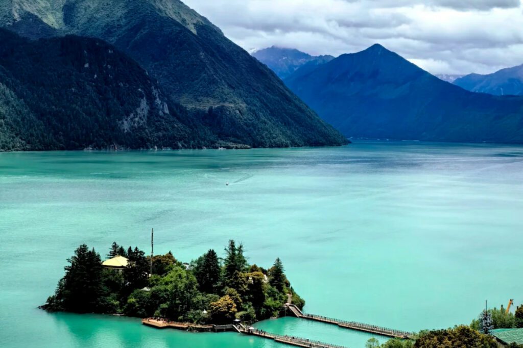
Mabunyonchu (Sacred Lake)
The lake is as clear as a mirror, and the reflection is especially beautiful at dawn and sunset, making it a hot spot for praying and photography.
Jilong (Green Valley on the Sino-Nigerian Border)
Located in Gyirong County, Rikaze City, Gyirong is one of the most important ports of entry from Tibet to Nepal. Compared to the Ali Plateau, Gyirong has a lower altitude, dense forests, and a temperate climate, making it the most beautiful green valley in the Himalayas. The snow-capped peaks, clouds and streams overlap with the valleys, presenting a green landscape that is very different from that of the plateau.

Jilonggou is a border town where Tibetan and Nepalese styles blend naturally, with cloud forests, hanging bridges and terraced villages. Strolling along the old streets, the spice scent mixed with the mountain air is very different from the coolness of the Ali Plateau - this is a place where the body and mind can be eased after turning into a mountain. The fog is thickest in the early morning or after a rain, making it the best time to photograph the valley and the sea of clouds.
In terms of itinerary, the Ali route can be planned as "Gangrenpoqi-Marbunyongcho-Saga-Jilong-Lhasa" or in the reverse direction, which can be flexibly adjusted in accordance with the policies of the border crossing points and the road conditions.
Attentions.
- Border Management:Ports and border control areas are governed by policy, so please follow the regulations and have valid documents.
- Climate and equipment:The humidity in the valleys is high, so be prepared with a waterproof jacket and non-slip shoes; be aware of the risk of rockfalls and flash floods during the rainy season.
- Cultural Etiquette:Consult before photographing residents or religious facilities, and avoid interfering with local religious activities.
Transportation and Accommodation in Houzang and Ali
The road conditions in the Ali region are complicated, with both long highland distances and gravel roads, and special attention must be paid to falling rocks and standing water during the rainy season. It is recommended to use a small off-road vehicle for better mobility and a more stable trip. In terms of lodging, conditions in the county town are relatively perfect; basic lodging is available around the scenic area, so it is recommended to bring enough warm clothing and personal cleaning supplies.
Rhythmic Arrangement
by "Gradual elevation, segmented adaptation"Avoid long walks or ascents on the first day; daytime driving, early closing and early resting are preferred.
Equipment and Plateau Adaptation Highlights
- Layering clothes:Wicking layer + warm layer + windproof and waterproof jacket.
- Footwear:Non-slip hiking shoes and spare socks; trekking poles can reduce the burden on knees and ankles.
- Supplies and power:Thermos, glucose or energy bar, mobile power and plug (rechargeable at some stations).
- Daylighting and Care:High-performance sunscreen, lip balm, sunglasses (UV/CPL recommended).
- Plateau Response:Stay in Lhasa for 1-2 days and travel according to your ability; if necessary, prepare high altitude medicine and portable oxygen as advised by your doctor.
Faith in Ali
Gang Rinpoche is not just a mountain, it's a place where you can face yourself again. When you are ready, go. With safety as the premise and rhythm as the core, incorporating Marbunyongtse, Layangtse, Guge Dynasty and Zada Tulin into the itinerary, you will be rewarded with a trip to the plateau that is full of both vision and soul.